Download
Quickstart Description Detailed Description
in order to download the free trial version, click one of the links below, save the
file, install and start GPSResults.exe
GPSResults V6.190 for Windows® 11, 10, 8, 7
Required: Microsoft Redistributables: VCRedist_X86
commercial usage of the program, e.g. for evaluation of contests is explicitly
not allowed without consent of the author.
Please request more infos from: info@gps-
The software is provided without any warranty, expressed or implied, including without limitation warranties of merchantability or fitness for a particular purpose. In no case shall the program author be liable for any loss of profits or any other commercial damage, including special, incidental, consequential or other damages
occasioned by use of this software.
last update: February 17, 2024
Version 6.190 PC
Added upload to SpeedJägerGermany
Version 6.188 PC
Added compressed file-format (GPY)
Version 6.187 PC
Added enhanced speed and altitude fields for FIT-format, fixed time-offset for OAO-files
Version 6.185 PC
Added number of satellites for FIT-format, fixed time-offset for OAO-files, added upload to SpeedjägerFehmarn
Version 6.182 PC
Minimum read speed for all file formats, improved scaling of list columns/rows
Version 6.181 PC
Enabled FIT-
Version 6.180 PC
Patched FIT-
Version 6.174 PC
Updated FIT-
Version 6.173 PC / 5.63 Mac
Replaced 20 sec by 30 minutes category, changed maximum acceleration for 10Hz units from 8 to 10m/s²
Version 6.171 PC / 5.62 Mac:
Added oao-
Version 6.161 PC:
http -
Version 6.160 PC / 5.50 Mac:
Upload of results to www.gps-
Version 6.151 PC / 5.44 Mac:
Fixed a glitch with negative timesteps
Version 6.150 PC / 5.43 Mac:
Fixed GPX-
Version 6.149 PC / 5.43 Mac:
Changed speed-
Version 6.148 PC / 5.42 Mac:
Improved handling of *.ubx-
Version 6.147 PC / 5.41 Mac:
Improved handling of *.fit files
Version 6.146 PC:
Improved handling of u-
Version 6.144 PC / 5.40 Mac:
Improved handling of ThingSee UBX 10Hz data
Version 6.143 PC:
Added support for SUUNTO Ambit3 GPX-
Version 5.39 Mac:
Added support for GW52 header and Thingsee UBX file format
Version 6.142 PC:
Added support for Thingsee UBX file format
Version 6.141 PC:
Fixed a problem with SBP-
Version 6.140 PC:
Fixed a problem with export to the latest version of GoogleEarth
Version 6.139 PC:
Fixed a glitch with positional data and Alpha categories
Version 6.138 PC:
FIT-
Version 6.123 PC, 5.36 Mac:
UBX corrupted file handling improved
Version 6.122 PC, 5.35 Mac:
24 hour results reviewed, upload of all run and track points added
Version 6.105 PC:
Custom website upload added, filter-
Version 6.104 PC, 5.31 Mac:
GPX-
Version 6.96 PC:
Averaging files from Doppler-
Version 6.90 PC:
Improved support of UBX-
Version 6.82 PC:
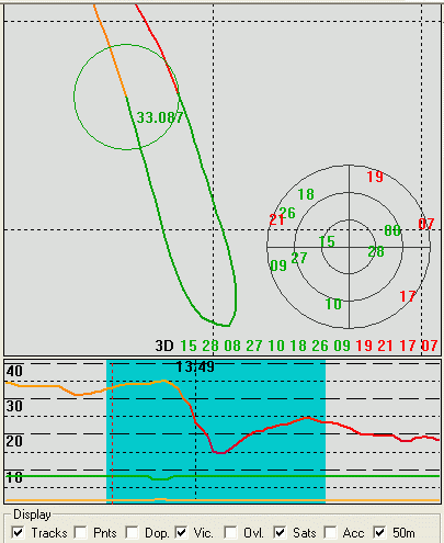
corrected speeds from two GT31 SDOP GPS units, gated speed measurements with segments of a circle, gatewidth can be modified by Ctrl & Mousewheel
Version 6.71 PC:
Bug in trapezoidal integration (2/10/20s categories) fixed
Version 6.70 PC:
Upload-
Version 6.63 PC, 5.27Mac:
Upload-
Version 6.61 PC, 5.26Mac:
Upload-
Version 6.60 PC:
Problems with files containing data with irregular sampling times fixed, Polarplot fixed
Version 6.55 PC, 5.25Mac:
Display bug fixed (could cause crashes), start-
Version 6.50 PC, 5.20Mac:
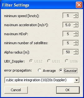
Improved Alpha-
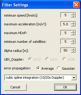
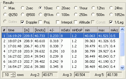
Average error (single GT31)
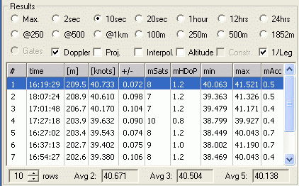
Gaussian error propagation (single GT31)
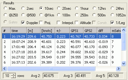
Average error (two GT31)
Gaussian error propagation (two GT31)
Version 6.10 PC:
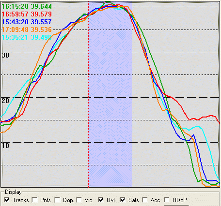
Overlay of fastest runs for comparison, Alpha categories improved, Alpha-
Version 6.02 PC:
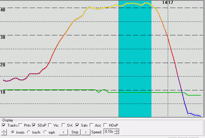
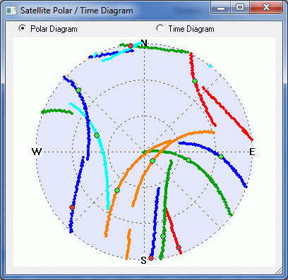
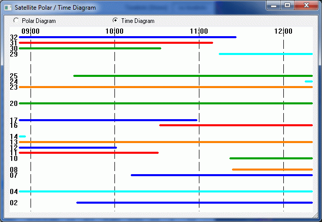
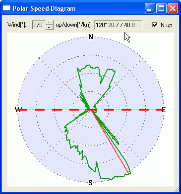
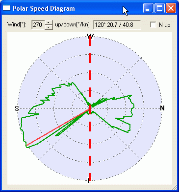
Polarplot with more functionality: adjustable wind-
Version 6.0 PC, 5.01 Mac:
SDOP values (GT31 Doppler-
Version 5.50 PC, 4.28 Mac:
Address for icesailing-
PC-
Version 5.49 PC:
Address change for kitespeed-
Version 4.23 PDA:
1 hour category deactivated due to performance issues
Version 5.48 PC:
Gated Doppler-
Version 4.26 Mac:
30 days trial period reset
Version 5.47 PC:
Timelimits (direct input) fixed, append files improved
Version 5.46 PC, 4.25 Mac:
Upload of unused alpha-
Version 4.24 Mac:
Nautical mile with jibe, Alpha 1NM deactivated
Version 5.45 PC:
Timelimits setting fixed, direct input of timezone possible
Version 5.44 PC:
Progress-
Version 5.42 PC:
Bug fixed in initialization of serial device list
Version 5.41 PC:
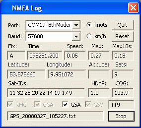
NMEA-
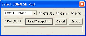
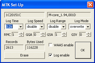
Version 5.40 PC:
Support for MTK-